Ras Mohammed and the islands of Tiran and Sanafir in South Sinai

Map showing location of Ras Mohammed and the islands of Tiran and Sanafir

Date of Announcement: 1983
Area: 850 km 2
Type: protected World Heritage
Distance from Cairo: 446 km
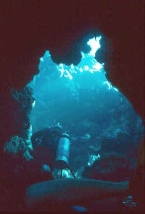
This reserve is located at the confluence of the Gulf of Suez and the Gulf of Aqaba, and represents the eastern edge of Ras Mohamed National Park rocky wall with the water of the Gulf, which are the coral reefs, and there are mangrove channel which separates the peninsula of Ras Mohammed and the Isle of Baerp length of about 250 meters. Featuring Ras Mohammed reefs, beaches in the deep ocean water to Ras Mohammed and colorful fish and sea turtles, endangered and rare water, and takes coral reefs of Ras Mohammed all aspects of marine and constitutes a unique configuration that this configuration where a significant impact in shaping the region's natural life as a landslides, "earthquakes" cave formation water to the bottom of the island as protected habitat for many important birds and animals such as: Ibex mountain areas and the types of small mammals, reptiles, insects, and that only appear at night, and that the reserve is home to many important birds such as gulls and Albulchunat.
Tiran Island
About 6 kms from the coast of the eastern Sinai, one of the islands and coral reefs, floating base is composed of granite rocks, old and disappearing under blankets sedimentary rocks are limited sources of water on the island of rainfall and floods in the winter clustered pits formed by rain and floods of winter Bimaptha rocks
Sanafir Island
There are west of the island of Tiran and about 2.5 km of which has the southern Gulf of open fit as a refuge for ships in an emergency.
2 - protected Zaranik and marsh Bardawil in North Sinai:

Date of Announcement: 1985
Area: 230 km 2
Type: Wetland protected Ratabp and a natural for the birds
Distance from Cairo: 300 km
Are protected Zaranik natural marsh Bardawil one of the keys to the migration of birds in the world with a first stop for the convenience of birds and access to food, the hard journey of immigration from Europe and Asia during the fall, heading to Africa also maintains some birds in the region permanently and reproduce them. Been recorded more than 270 species of birds in the reserve account for 14 species and most birds that have been recorded: pelicans, flamingos, heron, cattle egret, storks, Mirza chicken, hawk, quail, Almrap, Anz House, capped Lark, whistling, jokes, Abu Headers Alexandria, Ahadjwalp.
3 - pack nature reserves Red Sea:


Date of Announcement: 1986
Area: 35600 km 2
Type: protected national parks and natural
Distance from Cairo: 1300 km
Elba area is located in the southeastern part of the Eastern Desert and mountains located on the border between Egypt and Sudan on the Red Sea area includes a box on the following distinct environmental models:
1. Mangroves and the lamp "mangrove" in the coastal zones
2. Limited areas of coastal sand dunes by growing vegetation of grass
3. Ranges of coastal saline land "Coastal marshes"
4. Coastal plain desert
5. Coastal mountains and the surrounding hills where there are oases of fog.
There are in these environments the majority of species of animals, birds, reptiles and medicinal plants and wild species Egyptian Mahdadp 0 reserves Elba consists of the following areas:
1 - Red Sea Islands and coastal mangrove forests
2 - the Abraq
3 - the Aldiib
4 - Mount Mailbox
4 - Ameed Reserve, Matrouh Governorate:

Date of Announcement: 1986
Area: 700 km 2
Type: Deserts and protected Biosphere
Distance from Cairo: 300 km
There are around 170 species of wild plants growing in different environments, whether the dunes or sand hills internal studies have shown that these wild plants have economic and medical benefits since there are about 70 species that can be used in medical and therapeutic purposes, including Ansal and wormwood and plantain and sorrel Almtnan and, as There are 60 species that can be used for different purposes including fuel Agrm such as grasses, shrubs, and a source of oils and soaps such as Anna-Ghoul, a human food such as onions, landscaping, such as tooth-Shayeb, the manufacture of ropes and roofs, such as bamboos, such as grazing and Dabaagh and Tafwa. There are also about 40 species of plants are important for its role in the environmental reserve of sand and building new layers 0 and no reserve, many wild animals (such as deer, foxes, rabbits, gerbils, layouts, sued the mountain, lizards, scorpions), and there are 14 species of birds of prey 0
5 - Islands Protectorate Saluga and Ghazal in Aswan:

This reserve is located within the Nile River, about 3 km north of Aswan Reservoir, and is a unique environment and distinctive Peixaiha vegetative natural, as it is a haven for many birds
Rare and resident and visiting birds. This reserve is characterized by the presence of about 94 species of plants were identified more than 60 species of rare birds and endangered species: Osprey, Purple Moorhen, which are extremely useful in environmental clean-up of pests and decaying remains of the time between the resident and visiting birds: bittern, hoopoe , Egyptian geese, bee, bird paradise, a nightingale, and others.
6 - protected Ostom beautiful and the island of tennis in Port Said Governorate:

Date of Announcement: 1988
Area: 180 km 2
Type: Wetland protected Rdobpoumazl natural for the birds
Distance from Cairo: 200 km
Include the beautiful and protected harbors Ostom beautiful lake status as the island is located in Lake Tennis Almenzlpo Lake status with the largest space between the delta lakes, their systems are characterized by diverse environmental 0 Lake area was rich farmland status perfectly tender dropped its territory due to the earthquake, which occurred in the late sixth century AD, Aftgy sea water and broke into the sand dunes that separates between the sea and the agricultural land covered by water and took year after year until the flooded area, except for the famous tennis and was a great wide deferral buildings full of traders and livelihoods, and where palm trees, vineyards and farms, and by streams of high the land from which water flows into the sea from all the gulfs is now known and named Balostom Btnes relative to the tennis son of Ham son of Noah.
Is protected Ostom beautiful Port Said at a distance of 7 km west of Port Said on the coastal road between Port Said, Damietta, an area about 35 km 2, The island is located in Lake Tennis status at a distance of 7 km to the south west of the city of Port Said, including Tel richest tennis, and covers an area of the island about 8 km 2.
This reserve is characterized as being a major stop for migratory birds for the supply of food and rest during the journey in the seasons "spring and fall," as characterized by the existence of diverse ecosystems, which works by multiple organisms.
One of the main birds that migrate to the reserve: ducks Ahamray, Albulbol, constituency, nightingales, bird Akhawadp.
And fish: mullet, Alhnchan, Altobar, grouper, seabream, seabass and tilapia. The island of tennis there are fossils and the effects of the Ayyubid period.
The aim of protected areas to conserve natural resources of Lake downloaded from degradation and development of seed for the prevention of fishing straits.
7 - St. Katherine Protectorate in South Sinai:

Located in the South Sinai governorate on a high plateau surrounded by high mountains, one of the most important areas of religious tourism, where the Monastery of St. Catherine's church and library, a mosque inside the monastery due to the Fatimid era, the prophet and the prophet Saleh Haroun and the Valley of comfort and forty-valley and the mountains of Moses, Abbas and Safsafa and the highest summit mountain in Egypt (Mount Catherine and a height of 2637 meters), and there are a number of plants and animals and birds.
Date of Announcement: 1988
Area: 5750 km 2
Type: protected natural heritage and cultural world
Distance from Cairo: 550 km
Region is characterized by its proximity to the highest peaks in Egypt and was the emergence of these summits is one of the results of those great tectonic movement called the African Balkhosv greatest that has occurred since about 24 million years ago, giving rise to the Red Sea and Gulf of Aqaba, which become a destination of tourists from all over the world have protected St. Catherine's on the wealth of natural and cultural heritage much the same as that of the natural desert habitat for many flora and fauna. Examples of natural resources existing in the St. Katherine Protectorate:
Wildlife
Represented in the species of mammals, including Altil Nubian Egyptian deer, hyrax, Sinai tiger, wolf, hyena, fox, Hardun and Groundhog Arab and mouse cord and gerbils, etc. and there are 27 kind of reptiles such as snake and lizard and Tarisha and Alorl and living and other
Flora
The region contains 22 of the 28 kind of unique factions in the world, located in the Sinai, such as HH and knitting and Caper, thyme, wormwood and Agrm Batheran and Blink and drunk and other medicinal plants, poisonous plants, and others.
Archaeological heritage
Is in the presence of a large number of churches and monasteries such as the Monastery of St. Catherine and the effects of age Albezntykma are the effects due to the Pharaonic era and the subsequent ages.
Landscape
Region is characterized by high as the surface of the sea and the mountains and high peaks of the highest mountains in Egypt, such as Mount Catherine, Moses and garment WAM Schumer and bibliography mountainous landscapes and oases on the springs and wells is one of the unique scenic landscapes in the world.
8 - Al-Alaqi Valley in Aswan:

Date of Announcement: 1989
Area: 30000 km 2
Type: Deserts and protected Biosphere
Distance from Cairo: 950 km
This valley is a large dry river that was born of the Red Sea hills, especially from Mount packet and after the construction of the High Dam and Lake Nasser is full of water entered the water and Wadi Al and became a part of the lake, due to lower water levels receded, the lake water for a large part of this valley and has become covered with water. And where there are green and fertile soil and sponsor animals in the valley. Wadi Al is a good example of the dry lands, but it displays a stunning and rich in various types of flora have been recorded about 92 species of plants.
9 - Taba Reserve, South Sinai Governorate:

Impact of natural and protected area management of natural resources
Site (south of Taba in the north to by St. Catherine - cough) to the south
Construction resolution (No. 316 of 1998)
Area (2800 km 2)
Taba Reserve aimed at preserving the environment, particularly the geological formations and scenic deployed within the protected areas (oases and groove stained eyes water), and also to establish integration between wildlife conservation "environments and the diversity of life" marketing innovation "works created between the nomadic and the development of conscious, and to maximize the benefits for the local population of nomads, which is also of cultural and civilizational heritage indispensable due to the 5000 BC 0
»Diversity of wildlife in protected Taba very rich as it includes over 25 species of mammals, including feathers or a cat (an animal smaller than the Leopard) and gazelle and Nubian ibex and hyrax, also contain more than 50 species of birds such as the brown eagle, golden eagle, eagle and Egyptian vulture, and hawks and punishment bearded and pasture, and includes about 24 kind of reptiles, two of them were not present in the Sinai, but only two snake Sinai Shifter bullet and the serpent and the flora is very rich.
• Groove color:
• The groove colored as a result of weathering rocks the Nubian Sandstone, which is characterized by different colors, which give this groove Almnzertabiei distinctive and is one of the most important areas worth visiting in Sinai, Egypt as a whole, this groove-like formations in the "area of Petra" in Jordan, a Dai and roomy, whenever we go by gradually narrows until it becomes in some places very narrow at passers-by as the breadth not more than one meter Svhin only between sandstone at an altitude of about 50 meters from the bottom of the valley, and the phenomenon of the famous sandy hole with different colors of white to yellow with some red color in the gradient 0
• Rock engraved:
• There is one near Cktan Shahyrtan and Dai-Ghazaleh and the other near the small mountain Rum, and rocks to sandstone deserves to be seen as it is an isolated and lonely landscape of desert scenery covered with some of the writings of different languages, dating to between the second century BC and the second century AD There is also a the writings of ancient Greece, which chronicles the construction of the monastery of St. Catherine during the third century Hebrew, Roman, Byzantine and also during the Crusades, and there are inscriptions and religious symbols and images of animals, in some forms there are images of animals long since disappeared from the region, and here can see the form and Wildlife were living in the past 0
•
• dynamics:
• There are many sites named Balnoames, a set of houses or graves of prehistoric non-existent except in the central Sinai only, have been constructed in the form of a circular stone so that the door in the west, approximately equal diameter, about 5 meters high and 2 meters, The dynamics of the oldest what was built by humans between 4000 to 5000 years before now 0
• Bay Fayyord:
• The Sinai visitors can note the most spectacular in beauty and unique due to convergence between the sea and the land component of the beaches in the most fascinating, and provides management of the reserve facilities for visitors, and there are Haftin of the bay in the sea, making it one of the most famous dive sites in the northern part of the Gulf of Aqaba 0
• Appointed Greener:
• a green oasis in a sea of sand and visited frequently in Taba and protected them an easy way to get by St. Catherine asphalt and the highest honors and led to large-mount worthy of rum and Mount and the site of a car is bumpy and difficult, and the site can be accessed through the colloidal or Die from the area near the carved rock, and there was appointed by the pure natural and the emergence of the eye due to the intersection of the sandstone (Paleozoic Paleozoic) boycotted the underground (lower one) component of the ground-water basins, and can visit the groove near the white of the eye, the place has been processed km planned management of protected Taba in Bedouin tents and Larache and bathrooms as you can spend the night the place was welcomed and the Department of nomadic sites 0
• Ain Um Ahmad:
• The Oasis one of the most beautiful oases and demand of visitors, and the oasis is located down and Dai Zljh at an altitude of about 600 meters and located in areas along the main wadi, and there by small gardens and palm orchards, and the source of stream water and Dai Zljh which ran gathered in the sandstone, making it One of the major sites for eco-tourism
10 - Wetland Reserve Burollus in Kafr El Sheikh:

Date of Announcement: 1998
Area: 460 km 2
Type: Wetland protected Ratabp
Distance from Cairo: 300 km
Lake Burullus the second largest natural lake in Egypt in terms of area and there is Lake Burullus a number of environments the most important salt marsh and bronchial and sand plains, and on the shores of the lake there are sand dunes, and each of those environments, the properties of a soil constituent, and reflected the importance of these environments terms of it being a natural place for about 135 plant species and ground water. The moist environments play a big role in the reception of wild migratory birds 0
Burullus Lake is located northeast of the Rosetta Branch, Kafr Al-Sheikh, stretching the length of 70 kilometers and varies in width from 6 to 17 km, Mthblg area of 460 km 2 (110000 acres) and is the second largest natural lake in Egypt.
There is Lake Burullus a number of environments, the most important salt marsh and bronchial and sand plains, and there on the shores of lake sand dunes, so they are a natural place for about 135 plant species and ground water, in addition to being well suited to receive the migrating wild birds.
The aim of protected areas to biodiversity conservation lake status through the protection of habitats and organisms of plant and animal, and the resettlement of those species that became extinct due to human activities, and monitoring of environmental variables in the lake and the protection of wetlands. It also aims to promote the protection of eco-tourism and scientific research and applied research, and conservation of natural resources and in particular that have an economic return.
11 - protected bush coastal province of Sinai:

Area: 8 km 2
Type: Protected Resources Development
Distance from Cairo: 370 km
Is protected jungle areas of sand dunes as high as about 60 meters from the sea and covered with high density of acacia trees and some eucalyptus and tamarisk trees, shrubs, herbs and plants pastoral and other fodder, making it a resource for pasture, timber and shelter for wild birds and animals, and work to stabilize sand dunes and warbers located within the scope of protection to keep one form of the important habitats of the Mediterranean coast 0
Reserve lies in the northeast corner of Egypt North Sinai Governorate and on its borders with the State of Palestine and the total area of about 6 km 2 areas of sand dunes as high as about 60 meters from the sea and covered with high density of acacia trees and some eucalyptus and tamarisk trees, shrubs, herbs and plants pastoral and other fodder, which are all on the sand dune fixation and warbers located within the scope of protection to maintain a form of the important habitats of the Mediterranean coast, which suffered most of the development operations and development, but their shape and components of natural and work within a high density of vegetation to stabilize the water in the soil maintains the level groundwater and Adhuptha It is also working to increase the tourist attraction of the region as it contains the region from natural resources.
The area is one of the sources which the State seeks to preserve and protect them as one of the areas expected to have a positive impact on the protection of soil and dense vegetation, water resources, mammals, reptiles and wild birds, both resident and migratory birds.
12 - Wadi Tigris in Cairo:

Area: 60 km 2
Type: protected desert land
Distance from Cairo: 10 km
The valley of the Tigris important valley which stretches from east to west length of 30 km, passing rocks of limestone that was deposited in the marine environment during the Eocene era in the Eastern Desert (60 million years ago), so it is rich in archaeological digs, and reaches an elevation of the rocks on the side of the valley, about 50 m and is fed by a group of valleys on both sides. Includes a set of Valley living animal, including species of mammals such as: - deer - Alteatel - Rabbit Mountain - Red Fox - Rishi mouse tail - eggs - mouse Abu Shok - Abu bats and other small tail, and insects: Parkinson's disease - Abu-Eid - tiger bed - lion ants and many other kinds, have been recorded 18 species of reptiles. Affected by rain water that falls from the waterfalls on the rocks of limestone over the ages, where she formed the so-called Tigris Canyon, which somewhat resembles the "Grand Canyon, USA.
Is the Tigris River valley east of Maadi in Cairo in the Eastern Desert and is one of the important valley which stretches from east to west length of 30 km and a total area of about 60 km 2 and is going through limestone rocks, which deposited in the marine environment during the Eocene era of the Eastern Desert (60 million years ago) so it is fossil rich, with a rise in those rocks on both sides of the valley about 50 m and was injured by a group of valleys on both sides.
Includes a set of Valley living animal, including species of mammals, such as: Deer - Rabbit Mountain - Red Fox - Rishi mouse tail - eggs and many other kinds of insects, was also recorded 18 species of reptiles so far, including the Egyptian Tortoise - Alsagnkor planned - Abu leprosy Coffee - Snake Coupler and others also were recorded 12 bird species representing the environment of the Eastern Desert resident and migratory birds, and plants for the entire directory was registered 64 species of plants, such as: Basketball - Alratrit - grasses and other plants, either a medical or pastoral or fuel.
The impact of rain that fell throughout the ages on the rocks of the limestone to form the so-called "groove Tigris" "Canyon," which somewhat resembles the "Grand Canyon" in the United States as they appear in small wells with high concentrations of rainwater.
13 - The Fossilized Forest Reserve in Maadi, Cairo Governorate:
Date of Announcement: 1989
Area: 7 km 2
Type: Geological protected area and national heritage
Distance from Cairo: 30 km
Region is rich in petrified forest density of legs and trunks of trees in the composition of fossil wood and mountain, which belongs to the era Aloolijusyny consists of layers of sand and gravel and a child and fossilized wood thickness ranges 70 - 100 m. It is remarkably rich in the remains of trunks, stems, large petrified trees, which take the form of Slater sections of cylindrical ranging in size from centimeters to several meters, and gather together in the form of fossilized forest. Therefore, it is likely that the composition of Maadi Petrified Forest due to a branch of the Nile River since ancient geological times immemorial, has led to these trees and long-distance speech in this place then Thfr (petrified).
Is a petrified forest in Maadi (a suburb of Cairo), which was formed over millions of years from the time the third periods Alcaenozoi, called on the petrified forest in many scientific references the name of the mountain wood.
This is the geology of the region have rarely does not unprecedented in the world in terms of expanding and updating.
Location:
The Fossilized Forest Reserve is located some 18 kilometers east of the town of Maadi in Cairo Governorate north of the road Katameya - Al Ain Sokhna.
And the Fossilized Forest Reserve in Maadi is a plateau is almost flat with some hills and cliffs, and covers an area protected for the most part composition Wood Mount Aloolijusyn era of the "32 - 35 million years."
There is also a jungle density of stems and trunks of trees in the composition of fossil wood and mountain that belongs to the era Aloolijusyni This sediment is poor in fossils and remains of the non-rich that it significantly and the remains of trunks, stems, large petrified trees, which take forms of Slater Schlesip of cylindrical sections, ranging in size from centimeters to several meters, which join together in the form of fossilized forest.
14 - Al-Wadi Assiouti Assiut Governorate:
Date of Announcement: 1989
Area: 35 km 2
Type: protected propagation and multi-purpose
Distance from Cairo: 400 km
Protected Area is divided into two main sections:
1 - breeding and propagation of wild animals
There are possibilities of breeding and propagation of Egyptian deer, mountain goats, bighorn, ostrich, zebra and some reptiles
2 - breeding and propagation of plant germplasm
Where the need to hold assets threatened plant species and particular types of palm trees, shrubs, flowers and ornamental plants, cactus, juicy and aromatic and medicinal plants, which are genes for important economic crops, this next Alonoa p other plant species, especially endangered species of them have been farming several species in the protected area where they are asset accumulation of wild surrounding areas for reproduction
The reserve is situated in the Coast strange sound in the Eastern Desert on the road to Assiut / Cairo Desert east coast south of the city of Assiut, about 20 km, is bordered by the Eastern Desert to the north and the south and east and the village of strange sound to the Center for the coast of Assiut Governorate of the West.
The main objectives of protected Assuit Valley in maintaining plant and animal species and the maintenance of living natural resources and preserve the health of ecological processes in the ecosystem and the preservation of genetic biodiversity.
1 - This Web site is safer for the presence of water needed for drinking, food and shelter animals.
2 - The presence of protected farm, in the face of Assiut University feature can not be overlooked in terms of the existence of all the scientific expertise required from the university.
3 - the occurrence of protected land on the road to talk Cairo / Aswan protected given a strong impetus to accomplish its mission in addition to substantial reduction of operating expenses for the means of access to the lowest potential available.
1 - breeding and propagation of wild animals:
Began to appear deer in the protected area as a result of the availability of water and vegetation and there are prospects for breeding and propagation of mountain goats and bighorn sheep and ostrich and zebra and some reptiles.
2 - breeding and propagation of plant germplasm:
There is an urgent need to collect plant endangered species of plants, especially medicinal and aromatic plants such as drunk and Abbarriet, and others which are genes for important economic crops, this next Alonoa p other plant endangered species such as palm and Doom as well as maintaining legume germplasm.
15 - Wadi Rayan in Fayoum Governorate:

Date of Announcement: 1989
Area: 1759 km 2
Type: protected resources and the development of a natural national heritage
Distance from Cairo: 150 km
Characterized by the Wadi El Rayan desert environment integrated with its sand dunes, natural springs, water bodies and wide and various plant life and wild animals and a variety of important marine excavations and diverse as the Al Rayyan area lakes calm and natural environment free from pollution. The Wadi El Rayan following important areas:
Central Cascades
Areas are formed by groupings agricultural drainage water. It is a place for various sea sports.
The eyes of Al Rayyan
Consisting of longitudinal sand dunes, mobile intensive and there are four natural sulfur springs, and is characterized by the presence of plants containing 16 species of desert plants and about 15 species of wild animals feeding mainly deer and white Egyptian deer, fennec, sand fox, red foxes, and other 16 species of reptiles and over the 100 species of resident and migratory birds.
Jebel Al-Rayyan - Mount Almcajabijp
And includes the deep gullies and rock Mufelloukp know, one of the favorite places to see a panorama of Wadi El Rayan and picnics.
Whales valley
Is an area of the excavations in the northwest of the Wadi Rayan protectorate dated back to about 40 million years old, these fossils of the structures of the fossilized teeth of sharks and primitive sharks and shellfish and other marine animals, which is an open museum also has a plant within the rocks Aelchorp fossilized soft.
The importance of Wadi El Rayan because it is a natural environment for endangered animals such as deer and white Egyptian deer, fox fennec, sand fox, wolf, and rare migratory birds such as falcons and a hawk-Ghazal and Peregrine Falcon and punishment Alencary p relented and other migratory birds such as ducks and relented p quail Altvlq relented and p heron and goats, and others. Wild plants, such as: Aqool - zygoghyllum - Acol - rush - the jungle - reeds - Algrdq - Halfa, and others.
16 - Lake Qarun Reserve Fayoum Governorate:

Date of Announcement: 1989
Area: 1385 km 2
Type: Wetland protected Ratabp
Distance from Cairo: 90 km
And one of the oldest natural lakes in the world and the rest of Lake Morris old and the availability of the world famous fossil deposits of sea and river and continental dated back to about 40 million years, including a huge animal Fayoum rhinoceros-like and had a huge mouth of a river courses Trsepep lived upon the ancestors of elephants old with an animal-Fayoum and ancestors of hippopotamus, as well as dolphins and there are sharks, the ancestors of birds that live in Africa as it emerged the oldest fossils of a monkey in the world Egibtobzqs which dates back to the age-old Aloolijusyn and the presence of some fossilized trees. Region has a great variety of kinds of reptiles, amphibians and mammals that are of great importance in the environmental system of the Reserve. There are many historical monuments north of Lake Karun represents cultural heritage that is being exploited for tourism, dating back to the Pharaonic and Roman times and the lead continent in the northeast of the lake and the churches and Deir Abu Lifa.
Karun pool is located in the northwestern part of the Wadi El Rayan and Fayoum Governorate, one of the oldest natural lakes in the world, the rest from the old Lake Morris, the reserve is characterized by the presence of geologic formations that are scientifically and historically important, and by a variety of plants, and are flocking to a lot of migratory and resident birds. The discovery of mammal fossils have been dated back to the reserve, about 10 million years ago, emerged as the oldest fossils of a monkey in the world and some fossilized trees, and there are some areas of the ancient Pharaonic, Romanian, such as: the area of churches and the Temple of jewelers Palace and the Temple of the Karun and others, as well as some plant and animal fossils.
The blessing a group of live fish, such as: green tilapia, seabream, seabass, mullet, and there Lebaa some invertebrates, such as: white shrimp.
17 - Dome of the well-protected in Giza:

Date of Announcement: 1989
Area: 1 km 2
Type: Geological protected
Distance from Cairo: 23 km
Is good museum, protected by a dome and specialized scientific institute that helps in studying earth science and geological formations of different folds and fault lines can also be compared with similar formations in other places, and the existence of the gathering in fossil colonies makes full conservation of the dome of the good ideal for the study of fossils or the science of ancient life and also features the ancient environment and the extent of climate change that has happened to this region in particular during the upper Cretaceous period, which characterized this dome. The colonies of coral fossils that characterize the region of the best guiding fossils that indicate the old environment, so these marine fossils represent a complete record of the date the old one.
It lies on Cairo / Alexandria desert road in Giza.
Covers an area of about one square kilometers.
Featuring the installation of protected geological complex, which is part of the installation of the largest known installation Abu Rawash due to the convexity of the modern era in the late Alkritaoy led to the formation of a complex series of domes and Almqarat, turned the area into an island of Alkritaoy Top remained high, and is located on the line that linking folds convex regions cave Sinai Mara Abu Rawash to Bahariya Oasis, and therefore they represent a unique geological phenomenon.
To reserve of global importance especially to geologists. Among the most famous plants that do not exist in the north of Egypt, but in this region plant "Celsolapacoa" a dwarf shrub vegetation, with a wooden trunk with the importance of grazing for all types of animals.
18 - protected cave and led Sanour:

Date of Announcement: 1992
Area: 12 km 2
Type: Geological protected area and national heritage
Distance from Cairo: 200 km
The protected area contains geological formations known as stalactites and stalgmites in a perfect beautiful formed over millions of years, where the formation dates back to the era of Middle Eocene about 60 million years by a leakage of aqueous solutions of calcium carbonate saturated through the roof of the cave and then evaporated, leaving the mineral salts that accumulated in the form of deposits of stalactites and stalgmites, cave extends a distance of about 700 m, breadth about 15 m and depth is about 15 m and the importance of this cave is due to the scarcity of these natural formations in the world and shed light on the ancient climate conditions in that region and the era of composition. Additionally, it allows researchers to conduct detailed studies compared in terms of the different nature of the environmental conditions that prevailed in the old age Eocene East 0
Located in the province of Beni Suef, about 70 kilometers southeast of the city built Sopf is characterized by the presence of geological formations known as stalactites and Balsed of alabaster formed over millions of years, due to age about 60 million years ago, the cave is important to the scarcity of such natural formations as it is of great importance for researchers .
Date of Announcement: 1992
Area: 12 km 2
Type: Geological protected area and national heritage
Distance from Cairo: 200 km
The protected area contains geological formations known as stalactites and stalgmites in a perfect beautiful formed over millions of years, where the formation dates back to the era of Middle Eocene about 60 million years by a leakage of aqueous solutions of calcium carbonate saturated through the roof of the cave and then evaporated, leaving the mineral salts that accumulated in the form of deposits of stalactites and stalgmites, cave extends a distance of about 700 m, breadth about 15 m and depth is about 15 m and the importance of this cave is due to the scarcity of these natural formations in the world and shed light on the ancient climate conditions in that region and the era of composition. Additionally, it allows researchers to conduct detailed studies compared in terms of the different nature of the environmental conditions that prevailed in the old age Eocene East.
19 - Nabq Reserve, South Sinai Governorate:

Date of Announcement: 1992
Area: 600 km 2
Type: multi-purpose protected
Distance from Cairo: 500 km
Is protected Nabq contains several important environmental regulations include:
Coral reef - sea creatures and land - the mangrove forests located quite heavily and there are also desert eco-systems and Jblipoatera and there are animals such as spinning, caribou, hyena, reptiles and many migratory birds and invertebrates Almkimpbaladavp to live some of the Bedouin tribes in the region 0 is the region with a tourist attraction for scuba enthusiasts , safari and bird watching 0
Located in the Governorate of South Sinai in the area between Taba and Sharm el-Sheikh, Wadi or infection, characterized by coral reefs and marine organisms and sea grasses and deserts, and there are a number of animals and migratory and resident birds.
Date of Announcement: 1992
Area: 600 km 2
Type: multi-purpose protected
Distance from Cairo: 500 km
Is protected Nabq contains several important environmental regulations include:
Coral reef - sea creatures and land - the mangrove forests located quite heavily and there are also desert eco-systems and Jblipoatera and there are animals such as spinning, caribou, hyena, reptiles and many migratory birds and invertebrates Almkimpbaladavp to live some of the Bedouin tribes in the region 0 is the region with a tourist attraction for scuba enthusiasts , safari and bird watching.
20 - Abu Jalom protected in South Sinai:

Date of Announcement: 1992
Area: 500 km 2
Type: protected landscapes
Distance from Cairo: 600 km
The significance of the Abu Jalom in the presence of special topography where the mountains are close to beaches, and it contains a variety of environmental systems of coral reefs and marine organisms and seagrass beds, lagoons and desert ecosystems and the mountain. Full of mountains, valleys, animals, birds and plants, which make the area a tourist attraction for the amateurs of diving, safari and bird and animal watching. The area comprises about 165 species of plants including 44 species found only in this region is famous for the cave system of protected underwater which extends to depths of up to more than 100 m. This system is unstable and very dangerous, so it is necessary to maintain this cave system and the system the environmental area, which is one of the tourist attractions of the region.
Abu Jalom is protected on the road between Sharm el-Sheikh and Taba area called Wadi Alrsash in South Sinai. Featuring a protected topography, in particular, where the mountains are close to the beach and they contain a variety of environmental systems of coral reefs and marine organisms and sea grasses, deserts, mountains, mountains and valleys full of wild animals, birds and plants, which make the area a tourist attraction for those interested in diving and safaris and bird watching and animals, as characterized by a multiplicity the presence of lagoons.
21 - reserves the River Nile in different governorates:

Date of Announcement: 1998
Area: 160 km 2
Type: Wetland protected Ratabp
Distance from Cairo: 144 Egypt's various governorates of the island
Is the River Nile and natural reserves of the 144 island provinces of Egypt and there are different along the course the President from Aswan to Delta Barrage number of 95 islets with an area about 32500 acres and is in the Rosetta Branch of 30 island area of 3400 feddans, Damietta branch of the 19 island area about 1250 acres and the total area of the River Nile, about 37150 acres.
River Nile extends for about 6825 km from its sources to its mouth and the Nile Basin covers an area of about 2.9 million km 2 and passes after entering the River Nile to Egypt at Wadi Halfa and the distance of about 300 km through a narrow valley surrounded by granite rocks or from the Nubian Sandstone of eastern and western banks to reach to the First Cataract at a distance of 7 km south of Aswan, the Nile River and extends up to the city of Cairo and extending north to the Delta Barrage, about 20 km long and is divided into two branches, Damietta and Rosetta, who pour into the Mediterranean.
Islands is the Nile River provinces of Egypt's various parks. Studies indicate that the number of these islands of 144 islands, there is along the main stream from Aswan to Delta Barrage area of some 95 island of 32500 acres, and there are 30 islands of the Rosetta Branch area of 3400 feddans, Shelters Damietta Branch 19 island area of 1250 acres.
The total area of the River Nile, about 37150 acres or the equivalent of 155 km 2, spread of the islands in the 16 governorates of the Republic are: (Aswan - Qena - Sohag - Asyut - Menia - Beni Suef - Giza - Cairo - Qalyubia - Menoufiya - Bank - Kafr Sheikh - Dakahlia - Damietta).
22 - Wadi Beauty Newer reserves in Egypt:

Date of Announcement: 2003
Area: 7450 km 2
Type: Deserts are protected
Distance from Cairo: 850 km
Site
The area lies on the sea in the southern province of Gaza and the Red Sea coast with a length of about 60 kilometers an average depth of about 50 km in the mountains of the eastern desert and about ten kilometers in the Red Sea.
The most important elements to be natural conservation
· Basin Valley Beauty: The area includes valley of beauty, one of the largest and richest valleys of the Eastern Desert and is distinct from other flowering plant communities and the development, which depend on many kinds of objects and types, including rare and threatened with extinction.
· Mount Hamata: One of the highest mountains of the Eastern Desert, which houses a great variety of plants and animals.
· Mangrove swamps (shura): It extends along parts of the coast, which represent some of the biggest and most important in the mangrove swamps of Egypt, a unique environment, very important, very sensitive and rare in the country.
· Coral reefs: The marine environment Vtdm some of the best coral reefs in Egypt, which still maintain the pristine nature and have an international reputation attracts tourists from around the world, and there are coral reefs along the coast or are immersed in the central islands of the sea.
· Sea grass: and the marine environment also includes some of the most important pasture grass in the Red Sea, which is of particular importance to some of the rare creatures and fish spawning.
· Offshore islands: There are also several islands in the region of international importance for breeding birds and sea turtles.
· Sandy beaches: the region has the most important marine turtle breeding beaches in Egypt.
· On Biological Diversity: The region has great diversity in the systems and natural environments and thus in the types of objects that depend on them, as well as environments of the region is very important for a large number of threatened species, whether on land or sea.
· Natural features and geological features: the region contains a distinct geological and scenery of high aesthetic value.